Top 10 Normandy D-Day Orientation Tips
Normandy Beach Head:
-
-
- Hold up your Right hand. Your thumb and index finger represent the American Beaches of Utah (Thumb) and Omaha (Index Finger). The middle finger represents the British Beach sector known as “Gold” and the ring finger represents the British Commonwealth beach sector known as “Juno” which was also known as the Canadian sector? The pinkie finger represents the British Beach Sector of “Sword”.
-
55 Miles:
-
-
- The total end to end distance from the western end of the Utah sector to the eastern end of Sword is approximately 55 Miles.
-
Bookends:
-
-
- Think of the American and British Airborne units as Book-Ends that served to contain and protect the flanks of the overall beachhead in the 5 beach sectors. The east end of the beach sectors (Sword Sector) was infiltrated by the British Airborne units of the 6th Airborne Division. The west end of the beach sectors (Utah Sector) was infiltrated by the American Airborne units of the 82nd and the 101st. Subsequent amphibious landings were concentrated on all 5 beach sectors and generally commenced to arrive at approximately 6:30 AM with slight variance.
-
Saving Private Ryan:
-
-
- was influenced by the happenings on Omaha Beach and specifically around Dog Green sector. The Dog Green Sector is closest to Vierville-sur-Mer hamlet. The movie actually portrays the action on Curracloe Beach near Wexford in Ireland about 2-hour drive south from Dublin. People expecting to see the extensive concrete casemates and bunkers portrayed in the movie will find a somewhat different setting. Omaha Beach has fewer concrete structures on the high ground than the movie.
-
Omaha Beach:
-
-
- is about 6 miles long or 10 KM. It is crescent shaped and has a fine sand with a slight reddish hue. The various sectors on the beach from west to east are Charlie, Dog Green, Dog White, Dog Red, Easy Green, Easy Red, Fox Green, Fox Red.
-
Draws:
-
-
- Omaha Beach had 4 primary exits off of the beach. These exits are referred to as “Draws”. From West to East are the D-1, D-3, E-1, E-3 Draws.
-
The 29th Infantry Division:
-
-
- landed on the western half of the beach and the 1st infantry division landed on the Eastern side. The 29th Infantry Division was ordered to land from west to east on Charlie, Dog Green, Dog White, Dog Red and Easy Green. The 1st Infantry Division landed primarily on Easy Red and Fox Green.
-
Opposing the American landings:
-
-
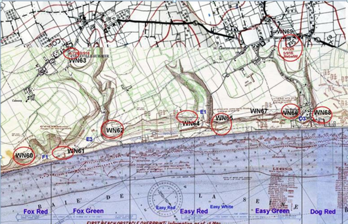
- on Omaha Beach were several German Bunkers. The German military called these positions “Widerstandsnest” – which translates roughly to “Resistance Nest”. Most maps of Omaha Beach will have a “WN” and a number next to it. The WN is an abbreviation of Widerstandsnest and the number is part of a sequence of other numbered WNs. The sequence of WNs is much like the Mailboxes you would find on a street. On or about Omaha Beach, the WNs going from West to East are: Opposing the 29th ID: WN 72, WN 71, WN 70, WN 68, WN 66, Opposing the 1st ID: WN 65, WN 64, WN 62, WN 61, WN 60.
-
Sequence of landings:
-
-
- Prior to the scheduled landings on the various beaches, there was Naval and Aerial bombardment. The purpose of this was to reduce or eliminate any forces opposing the Allied landings. One might ask why so many more casualties occurred on Omaha beach compared with Utah Beach. The reason is that the Aerial bombardment was done with an experienced tactical force of medium bombers that had 12 prior coastal battery missions. The medium bombers of the 9th AAF used 250 general purpose instant fuse bombs. On Omaha beach, by comparison, the strategic forces of the 8th AAF used 100lb instant fuse fragmentation bombs with a much lower effect. Most of the Utah beach WNs were decimated, whereas most WNs on Omaha were still intact. The only exception where larger bombs were used on Omaha beach is where the target was WN 71. For this target, 500lb general purpose instant fuse bombs were used. However, the location of where these bombs landed was too far inland from their intended target.
-
Cemetery:
-
-
- The well-known American Cemetery in Normandy is more accurately known as the Colleville-sur-Mer Cemetery. It is located in the Omaha Beach high ground between the E-1 Draw and the E-3 Draw. Looking down from the Cemetery to the beach below is the Easy Red beach sector which was a primary landing spot for the 1st ID. Off to the side of the cemetery where the parking lot is and toward to sea, is the WN 62 defensive position. It is an excellent place to look at the defensive positions made for that battle.
-
Bonus:
-
- Plan your time to visit the beaches based on the low tide. Being able to go out 300-400 yards on the beach, will help to provide a better perspective about how much distance and how vulnerable the American forces were as they landed.